
Make a donation
Gear up for your next adventure:
As an Amazon Associate, this site earns from qualifying purchases at no extra cost to you.
Anchayaku topographic map
Click on the map to display elevation.
Make a donation
Gear up for your next adventure:
As an Amazon Associate, this site earns from qualifying purchases at no extra cost to you.
About this map
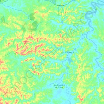
Name: Anchayaku topographic map, elevation, terrain.
Location: Anchayaku, Eloy Alfaro, Esmeraldas, Ecuador (0.85779 -79.22965 1.05370 -79.02091)
Average elevation: 44 m
Minimum elevation: -3 m
Maximum elevation: 170 m
Make a donation
Gear up for your next adventure:
As an Amazon Associate, this site earns from qualifying purchases at no extra cost to you.
Other topographic maps
Click on a map to view its topography, its elevation and its terrain.
Cordillera de Toisán
Ecuador > Esmeraldas > Eloy Alfaro > Luis Vargas Torres
Average elevation: 1,297 m
Make a donation
Gear up for your next adventure:
As an Amazon Associate, this site earns from qualifying purchases at no extra cost to you.