Geolocate

Saß topographic map

Click on the map to display elevation.

About this map

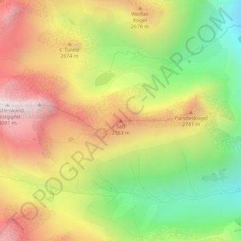
Name: Saß topographic map, elevation, terrain.

Location: Saß, Sankt Leonhard im Pitztal, Bezirk Imst, Austria (46.99660 10.83579 46.99670 10.83589)

Average elevation: 2,480 m

Minimum elevation: 1,899 m

Maximum elevation: 3,072 m

Gear up for your next adventure:

🧰Survival Kit - Essential gear for emergencies in the wilderness
🥾Lightweight Hiking Boots - Boots for comfort and mobility on long hikes
🥾Light Trekking Boots - Supportive boots for multi-day treks
Camping Groundsheet - Protect your tent from moisture and dirt
🕶️Polarized Sunglasses - Protect your eyes with durable polarized lenses

As an Amazon Associate, this site earns from qualifying purchases at no extra cost to you.