Geolocate

Singaparna topographic map

Click on the map to display elevation.

About this map

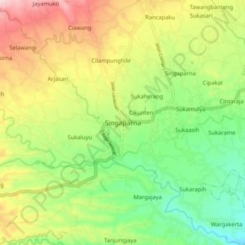
Name: Singaparna topographic map, elevation, terrain.

Location: Singaparna, Tasikmalaya, West Java, Java, 46412, Indonesia (-7.38991 108.07075 -7.30991 108.15075)

Average elevation: 433 m

Minimum elevation: 319 m

Maximum elevation: 587 m

Other topographic maps

Click on a map to view its topography, its elevation and its terrain.

Cipanas

Indonesia > West Java > Tasikmalaya

Average elevation: 117 m

Desa Arjasari

Indonesia > West Java > Tasikmalaya

Average elevation: 454 m

Desa Cimanuk

Indonesia > West Java > Tasikmalaya

Average elevation: 32 m

Gear up for your next adventure:

🥾Waterproof Hiking Boots - Boots keeping your feet dry in wet conditions
🧰Multitool Knife - Compact and versatile tool for outdoor use
🦶Hiking Shoe Insoles - Added support for high arches and long days on feet
🪜Heavy Duty Carabiners - Multi-use clips for securing gear to your backpack
Camping Groundsheet - Protect your tent from moisture and dirt

As an Amazon Associate, this site earns from qualifying purchases at no extra cost to you.