
Make a donation
Gear up for your next adventure:
As an Amazon Associate, this site earns from qualifying purchases at no extra cost to you.
Nances Creek topographic map
Click on the map to display elevation.
Make a donation
Gear up for your next adventure:
As an Amazon Associate, this site earns from qualifying purchases at no extra cost to you.
About this map
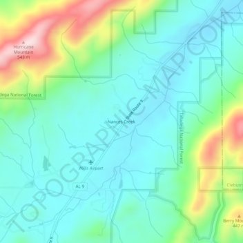
Name: Nances Creek topographic map, elevation, terrain.
Location: Nances Creek, Calhoun County, Alabama, United States (33.83788 -85.67691 33.87788 -85.63691)
Average elevation: 303 m
Minimum elevation: 215 m
Maximum elevation: 560 m
Make a donation
Gear up for your next adventure:
As an Amazon Associate, this site earns from qualifying purchases at no extra cost to you.
Other topographic maps
Click on a map to view its topography, its elevation and its terrain.
Piedmont
United States > Alabama > Calhoun County
Dugger Mountain, the second highest peak in Alabama with an elevation of 2,140 feet (650 m), is located just outside the city limits of Piedmont, which is the closest city to the peak and wilderness area.
Average elevation: 263 m
Make a donation
Gear up for your next adventure:
As an Amazon Associate, this site earns from qualifying purchases at no extra cost to you.
Make a donation
Gear up for your next adventure:
As an Amazon Associate, this site earns from qualifying purchases at no extra cost to you.