
Woburn topographic map
Interactive map
Click on the map to display elevation.
About this map
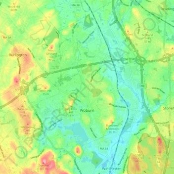
Name: Woburn topographic map, elevation, terrain.
Average elevation: 40 m
Minimum elevation: 4 m
Maximum elevation: 103 m
Other topographic maps
Click on a map to view its topography, its elevation and its terrain.
Bedford
United States > Massachusetts > Middlesex County
Bedford, Middlesex County, Massachusetts, 01730, United States
Average elevation: 45 m
Concord
United States > Massachusetts > Middlesex County
Concord, Middlesex County, Massachusetts, 01742, United States
Average elevation: 54 m
Wedge Pond
United States > Massachusetts > Middlesex County > Winchester
Wedge Pond, Winchester, Middlesex County, Massachusetts, United States
Average elevation: 25 m
Sherborn
United States > Massachusetts > Middlesex County
Sherborn, Middlesex County, Massachusetts, 01770, United States
Average elevation: 57 m
South Chelmsford
United States > Massachusetts > Middlesex County > Chelmsford
South Chelmsford, Chelmsford, Middlesex County, Massachusetts, 01824, United States
Average elevation: 65 m
Lost Lake
United States > Massachusetts > Middlesex County > Groton
Lost Lake, Groton, Middlesex County, Massachusetts, United States
Average elevation: 78 m
Institution Hill
United States > Massachusetts > Middlesex County > Newton
Institution Hill, Newton, Middlesex County, Massachusetts, 02459, United States
Average elevation: 53 m
Ashland
United States > Massachusetts > Middlesex County
Ashland, Middlesex County, Massachusetts, 01721, United States
Average elevation: 81 m
West Medford
United States > Massachusetts > Middlesex County > Medford
West Medford, Medford, Middlesex County, Massachusetts, 02474, United States
Average elevation: 19 m
Tyngsborough
United States > Massachusetts > Middlesex County
Tyngsborough, Middlesex County, Massachusetts, 01879, United States
Average elevation: 55 m
Zion Hill
United States > Massachusetts > Middlesex County > Woburn
Zion Hill, Woburn, Middlesex County, Massachusetts, 02476, United States
Average elevation: 60 m
Stoneham
United States > Massachusetts > Middlesex County
Stoneham, Middlesex County, Massachusetts, 02180, United States
Average elevation: 40 m
Belmont
United States > Massachusetts > Middlesex County > Belmont
Belmont, Middlesex County, Massachusetts, United States
Average elevation: 40 m
Marlborough
United States > Massachusetts > Middlesex County > Marlborough
Marlborough, Middlesex County, Massachusetts, 01752, United States
Average elevation: 98 m
Haywardville
United States > Massachusetts > Middlesex County > Stoneham > Haywardville
Haywardville, Stoneham, Middlesex County, Massachusetts, 02180, United States
Average elevation: 46 m
North Reading
United States > Massachusetts > Middlesex County > North Reading
North Reading, Middlesex County, Massachusetts, 01864, United States
Average elevation: 33 m
Framingham
United States > Massachusetts > Middlesex County
Framingham, Middlesex County, Massachusetts, United States
Average elevation: 70 m
Chelmsford
United States > Massachusetts > Middlesex County > Chelmsford
Chelmsford, Middlesex County, Massachusetts, United States
Average elevation: 55 m
Natick
United States > Massachusetts > Middlesex County > Natick
Natick, Middlesex County, Massachusetts, United States
Average elevation: 55 m
South Sudbury
United States > Massachusetts > Middlesex County > Sudbury > South Sudbury
South Sudbury, Sudbury, Middlesex County, Massachusetts, 01705-0604, United States
Average elevation: 53 m
Medford
United States > Massachusetts > Middlesex County
Medford, Middlesex County, Massachusetts, 02155, United States
Average elevation: 23 m
Cambridge
United States > Massachusetts > Middlesex County
Cambridge, Middlesex County, Massachusetts, United States
Average elevation: 11 m
Meriam's Corner
United States > Massachusetts > Middlesex County > Concord
Meriam's Corner, Concord, Middlesex County, Massachusetts, 01773, United States
Average elevation: 50 m
Waltham
United States > Massachusetts > Middlesex County
Waltham, Middlesex County, Massachusetts, United States
Average elevation: 48 m
Marlborough
United States > Massachusetts > Middlesex County
Marlborough, Middlesex County, Massachusetts, United States
Average elevation: 95 m
Acton
United States > Massachusetts > Middlesex County
Acton, Middlesex County, Massachusetts, United States
Average elevation: 66 m
Watertown
United States > Massachusetts > Middlesex County
Watertown, Middlesex County, Massachusetts, United States
Average elevation: 26 m
Tewksbury
United States > Massachusetts > Middlesex County
Tewksbury, Middlesex County, Massachusetts, 01876, United States
Average elevation: 42 m
Billerica
United States > Massachusetts > Middlesex County
Billerica, Middlesex County, Massachusetts, United States
Average elevation: 47 m
Melrose
United States > Massachusetts > Middlesex County
Melrose, Middlesex County, Massachusetts, 02176, United States
Average elevation: 38 m
Ayer
United States > Massachusetts > Middlesex County
Ayer, Middlesex County, Massachusetts, 01432, United States
Average elevation: 87 m
Westford
United States > Massachusetts > Middlesex County
Westford, Middlesex County, Massachusetts, 01886, United States
Average elevation: 69 m