Geolocate

Oliver topographic map

Click on the map to display elevation.

About this map

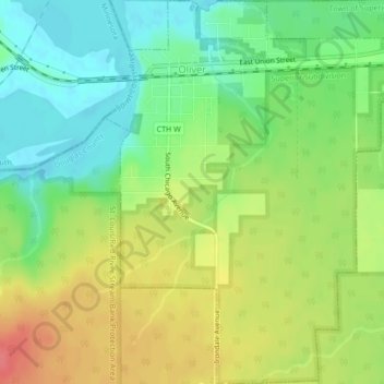
Name: Oliver topographic map, elevation, terrain.

Location: Oliver, Douglas County, Wisconsin, United States (46.63344 -92.20493 46.66265 -92.16978)

Average elevation: 207 m

Minimum elevation: 178 m

Maximum elevation: 243 m

Other topographic maps

Click on a map to view its topography, its elevation and its terrain.

Dairyland

United States > Wisconsin > Douglas County

Average elevation: 339 m

Hawthorne

United States > Wisconsin > Douglas County

Average elevation: 357 m

South Range

United States > Wisconsin > Douglas County

Average elevation: 237 m

Bennett

United States > Wisconsin > Douglas County

Average elevation: 368 m

Foxboro

United States > Wisconsin > Douglas County

Average elevation: 277 m

Gear up for your next adventure:

Camping Tent - Weather-resistant tents suitable for 2 to 6 people
🧥Waterproof Jacket - Lightweight rain jackets for hiking and outdoor activities
🧢Hiking Hat - Sun-protective and breathable hats for long treks
🧭GPS Outdoor Watch - Smart watch for navigation and fitness tracking in nature
🥾Hiking Leggings - Comfortable leggings for outdoor activities

As an Amazon Associate, this site earns from qualifying purchases at no extra cost to you.