Geolocate

Berkeley Lake topographic map

Click on the map to display elevation.

About this map

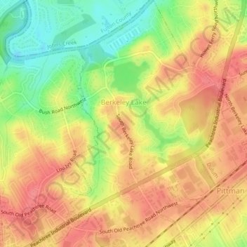
Name: Berkeley Lake topographic map, elevation, terrain.

Location: Berkeley Lake, Gwinnett County, Georgia, United States (33.96468 -84.19842 33.99707 -84.16939)

Average elevation: 311 m

Minimum elevation: 269 m

Maximum elevation: 338 m

Other topographic maps

Click on a map to view its topography, its elevation and its terrain.

Mountain Park

United States > Georgia > Gwinnett County

Average elevation: 292 m

Marsh Creek

United States > Georgia > Gwinnett County

Average elevation: 312 m

Duluth

United States > Georgia > Gwinnett County > Duluth

Average elevation: 304 m

Oak Village

United States > Georgia > Gwinnett County

Average elevation: 316 m

Hog Mountain

United States > Georgia > Gwinnett County

Average elevation: 337 m

Harbins Park

United States > Georgia > Gwinnett County

Average elevation: 271 m

Berry Lake

United States > Georgia > Gwinnett County > Suwanee

Average elevation: 304 m

Gear up for your next adventure:

Lightweight Backpacking Tent - Compact tent for efficient hiking trips
🥽Outdoor Goggles - Protective eyewear for outdoor activities
🥾Trekking Boots - Durable boots for long-distance trekking
🧤Insulated Winter Gloves - Heavy-duty protection for sub-zero Canadian adventures
🥾All-Terrain Hiking Boots - Versatile boots for varied hiking conditions

As an Amazon Associate, this site earns from qualifying purchases at no extra cost to you.