
Szigetmonostor topographic map
Interactive map
Click on the map to display elevation.
About this map
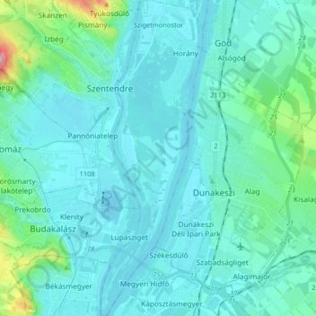
Name: Szigetmonostor topographic map, elevation, terrain.
Average elevation: 128 m
Minimum elevation: 98 m
Maximum elevation: 358 m
Other topographic maps
Click on a map to view its topography, its elevation and its terrain.
Danubio
Hungría > Pest vármegye > Dunakeszi
Danubio, Dunakeszi, Dunakeszi járás, Pest vármegye, Hungría Central, Hungría
Average elevation: 115 m
Danubio
Hungría > Pest vármegye > Budakalász
Danubio, Lupasziget, Budakalász, Szentendrei járás, Pest vármegye, Hungría Central, 2011, Hungría
Average elevation: 104 m