Geolocate

Sugar topographic map

Click on the map to display elevation.

About this map

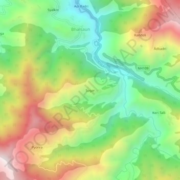
Name: Sugar topographic map, elevation, terrain.

Location: Sugar, Gairsain, Chamoli District, Uttarakhand, 246440, India (30.11724 79.20928 30.15724 79.24928)

Average elevation: 1,689 m

Minimum elevation: 1,212 m

Maximum elevation: 2,331 m

Gear up for your next adventure:

🧥Ultralight Puffy Jacket - Maximum warmth that packs down to the size of an orange
🚲Handlebar Phone Mount - View topographic-map.com live while cycling
🧤Rechargeable Heated Gloves - Extreme warmth for Canadian winter expeditions
🥾Waterproof Hiking Boots - Boots keeping your feet dry in wet conditions
🧴Insect Repellent - Protect yourself from bugs during outdoor adventures

As an Amazon Associate, this site earns from qualifying purchases at no extra cost to you.