
Thank you for supporting this site ❤️
Make a donation
Make a donation
Gear up for your next adventure:
As an Amazon Associate, this site earns from qualifying purchases at no extra cost to you.
L'Aumelle topographic map
Click on the map to display elevation.
Thank you for supporting this site ❤️
Make a donation
Make a donation
Gear up for your next adventure:
As an Amazon Associate, this site earns from qualifying purchases at no extra cost to you.
About this map
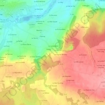
Name: L'Aumelle topographic map, elevation, terrain.
Average elevation: 88 m
Minimum elevation: 33 m
Maximum elevation: 135 m
Thank you for supporting this site ❤️
Make a donation
Make a donation
Gear up for your next adventure:
As an Amazon Associate, this site earns from qualifying purchases at no extra cost to you.
Other topographic maps
Click on a map to view its topography, its elevation and its terrain.
Le vallon de la Chambre au Loup
France > Bretagne > Ille-et-Vilaine > Iffendic > La Perrière
Average elevation: 93 m