
Make a donation
Gear up for your next adventure:
As an Amazon Associate, this site earns from qualifying purchases at no extra cost to you.
Potchefstroom topographic map
Click on the map to display elevation.
Make a donation
Gear up for your next adventure:
As an Amazon Associate, this site earns from qualifying purchases at no extra cost to you.
Potchefstroom
Potchefstroom has hosted two World Cup-winning teams (in cricket and football), and is a home away from home for international athletes and teams. At 1,400 metres (4,600 ft) altitude, it provides a good balance between altitude and quality training. The city has no large factories, and good air quality. Athletes and professional teams train at the North-West University's High Performance Institute of Sport.
Make a donation
Gear up for your next adventure:
As an Amazon Associate, this site earns from qualifying purchases at no extra cost to you.
About this map
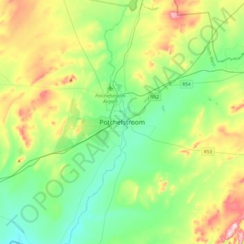
Name: Potchefstroom topographic map, elevation, terrain.
Average elevation: 1,392 m
Minimum elevation: 1,296 m
Maximum elevation: 1,612 m
Make a donation
Gear up for your next adventure:
As an Amazon Associate, this site earns from qualifying purchases at no extra cost to you.