
Make a donation
Gear up for your next adventure:
As an Amazon Associate, this site earns from qualifying purchases at no extra cost to you.
Petite France topographic map
Click on the map to display elevation.
Make a donation
Gear up for your next adventure:
As an Amazon Associate, this site earns from qualifying purchases at no extra cost to you.
Petite France
Théodore Kéranval fit construire sur cette propriété située à 1000 mètres d'altitude, une case changement d'air pour sa fille atteinte de paludisme. Elle est vendue à son gendre en 1879, Jean-Baptiste Lougnon.
Make a donation
Gear up for your next adventure:
As an Amazon Associate, this site earns from qualifying purchases at no extra cost to you.
About this map
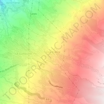
Name: Petite France topographic map, elevation, terrain.
Location: Petite France, Saint-Paul, La Réunion, 97423, France (-21.05772 55.29309 -21.01772 55.33309)
Average elevation: 749 m
Minimum elevation: 233 m
Maximum elevation: 1,141 m
Make a donation
Gear up for your next adventure:
As an Amazon Associate, this site earns from qualifying purchases at no extra cost to you.
Other topographic maps
Click on a map to view its topography, its elevation and its terrain.
Ravine Saint-Gilles
France > La Réunion > Saint-Paul > Saint-Gilles-les-Hauts > Village de l'Éperon
Average elevation: 310 m
Make a donation
Gear up for your next adventure:
As an Amazon Associate, this site earns from qualifying purchases at no extra cost to you.