Geolocate

Taruga topographic map

Click on the map to display elevation.

About this map

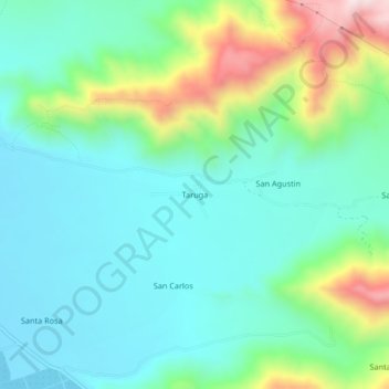
Name: Taruga topographic map, elevation, terrain.

Location: Taruga, Vista Alegre, Nasca, Ica, Perú (-14.93033 -74.94136 -14.89033 -74.90136)

Average elevation: 707 m

Minimum elevation: 563 m

Maximum elevation: 1,124 m

Gear up for your next adventure:

🛰️Satellite Messenger - Emergency communication for areas with no cell service
🧥Waterproof Jacket - Lightweight rain jackets for hiking and outdoor activities
🥾Waterproof Trail Shoes - Shoes designed to handle wet terrain
🚲MTB Frame Bag - Carry tools and maps directly on your bicycle frame
🧭GPS Outdoor Watch - Smart watch for navigation and fitness tracking in nature

As an Amazon Associate, this site earns from qualifying purchases at no extra cost to you.