
Make a donation
Gear up for your next adventure:
As an Amazon Associate, this site earns from qualifying purchases at no extra cost to you.
Clayton topographic map
Click on the map to display elevation.
Make a donation
Gear up for your next adventure:
As an Amazon Associate, this site earns from qualifying purchases at no extra cost to you.
About this map
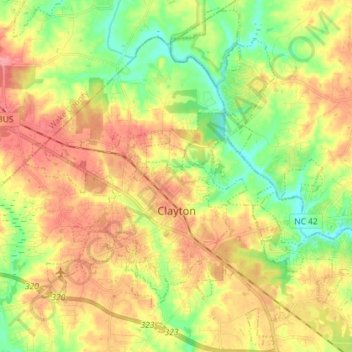
Name: Clayton topographic map, elevation, terrain.
Location: Clayton, Johnston County, North Carolina, United States (35.60621 -78.51888 35.71793 -78.37512)
Average elevation: 81 m
Minimum elevation: 39 m
Maximum elevation: 124 m
Make a donation
Gear up for your next adventure:
As an Amazon Associate, this site earns from qualifying purchases at no extra cost to you.
Other topographic maps
Click on a map to view its topography, its elevation and its terrain.
Willow Springs
United States > North Carolina > Johnston County > Willow Springs
Average elevation: 74 m
Make a donation
Gear up for your next adventure:
As an Amazon Associate, this site earns from qualifying purchases at no extra cost to you.
Country Estates
United States > North Carolina > Johnston County > Clayton > Country Estates
Average elevation: 89 m