Geolocate

Barton City topographic map

Click on the map to display elevation.

Barton City

Barton City is at 44°41′03″N 83°36′20″W / 44.68417°N 83.60556°W / 44.68417; -83.60556 (Barton City, Michigan) with an elevation of 830 feet (250 m) above sea level.

Wikipedia (CC-BY-SA 3.0)

About this map

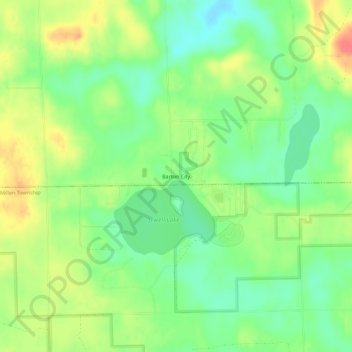
Name: Barton City topographic map, elevation, terrain.

Location: Barton City, Hawes Township, Alcona County, Michigan, 48705, United States (44.66418 -83.62553 44.70418 -83.58553)

Average elevation: 258 m

Minimum elevation: 233 m

Maximum elevation: 289 m

Other topographic maps

Click on a map to view its topography, its elevation and its terrain.

Harrisville

United States > Michigan > Alcona County

Average elevation: 188 m

Hawes Township

United States > Michigan > Alcona County

Average elevation: 246 m

Black River

United States > Michigan > Alcona County

Average elevation: 192 m

Hubbard Lake

United States > Michigan > Alcona County

Average elevation: 236 m

Gear up for your next adventure:

🧦Hiking Socks - Moisture-wicking and comfortable socks for long hikes
🎒Hiking Daypack - Lightweight and durable backpacks for day trips and excursions
🥾Trail Hiking Boots - Supportive boots for rough trails
🧴Insect Repellent - Protect yourself from bugs during outdoor adventures
Camping Groundsheet - Protect your tent from moisture and dirt

As an Amazon Associate, this site earns from qualifying purchases at no extra cost to you.