Geolocate

Malilipot topographic map

Click on the map to display elevation.

About this map

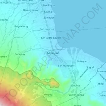
Name: Malilipot topographic map, elevation, terrain.

Location: Malilipot, Albay, Bicol Region, 4510, Philippines (13.27905 123.69927 13.35905 123.77927)

Average elevation: 112 m

Minimum elevation: -2 m

Maximum elevation: 824 m

Gear up for your next adventure:

🥾Lightweight Hiking Boots - Boots for comfort and mobility on long hikes
🕶️Polarized Sunglasses - Reduces glare from snow and water at high elevations
🧢Hiking Sun Hat - Wide-brimmed protection for exposed mountain ridges
🔨Vehicle Emergency Tool - Safety tool for remote road trips to trailheads
🛶Waterproof Dry Bags - Keep electronics and clothes dry during river crossings

As an Amazon Associate, this site earns from qualifying purchases at no extra cost to you.