Geolocate

Palanog topographic map

Click on the map to display elevation.

About this map

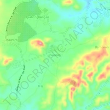
Name: Palanog topographic map, elevation, terrain.

Location: Palanog, Albay, Bicol Region, 4503, Philippines (13.12507 123.59287 13.16507 123.63287)

Average elevation: 149 m

Minimum elevation: 100 m

Maximum elevation: 239 m

Gear up for your next adventure:

🧥Waterproof Hiking Jacket - Protect yourself from rain and wind while hiking
💧Filtered Water Bottle - Safe drinking water on the go
🔦LED Headlamp - Hands-free lighting for early morning starts or late finishes
🧣Merino Neck Gaiter - Protects against wind, sun, and cold at high altitudes
🥾Waterproof Hiking Boots - Boots keeping your feet dry in wet conditions

As an Amazon Associate, this site earns from qualifying purchases at no extra cost to you.