
Make a donation
Gear up for your next adventure:
As an Amazon Associate, this site earns from qualifying purchases at no extra cost to you.
Linoudel topographic map
Click on the map to display elevation.
Make a donation
Gear up for your next adventure:
As an Amazon Associate, this site earns from qualifying purchases at no extra cost to you.
About this map
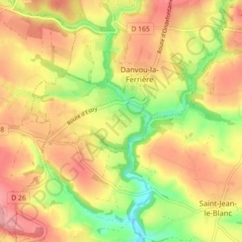
Name: Linoudel topographic map, elevation, terrain.
Average elevation: 223 m
Minimum elevation: 161 m
Maximum elevation: 271 m
Make a donation
Gear up for your next adventure:
As an Amazon Associate, this site earns from qualifying purchases at no extra cost to you.
Other topographic maps
Click on a map to view its topography, its elevation and its terrain.
Campandré-Valcongrain
France > Normandie > Calvados > Les Monts d'Aunay
Le point culminant (334 m) se situe au nord du bourg de Campandré, au mont d'Ancre, en forêt de Valcongrain. Le point le plus bas (123 m) correspond à la sortie du ruisseau de Vingt Bec du territoire, au nord-est. La commune est bocagère et forestière. Il fait face au mont Pinçon, le plus haut point du…
Average elevation: 238 m
Make a donation
Gear up for your next adventure:
As an Amazon Associate, this site earns from qualifying purchases at no extra cost to you.