
Saint Arnaud topographic map
Interactive map
Click on the map to display elevation.
About this map
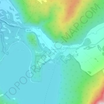
Name: Saint Arnaud topographic map, elevation, terrain.
Location: Saint Arnaud, Tasman, 7053, Nueva Zelanda (-41.82237 172.82504 -41.78237 172.86504)
Average elevation: 701 m
Minimum elevation: 602 m
Maximum elevation: 1,099 m
Other topographic maps
Click on a map to view its topography, its elevation and its terrain.
Lake Rotoiti
Nueva Zelanda > Tasman > Saint Arnaud
Lake Rotoiti, Lakehead Track, Saint Arnaud, Tasman, 7072, Nueva Zelanda
Average elevation: 1,031 m