Geolocate

Halang topographic map

Click on the map to display elevation.

About this map

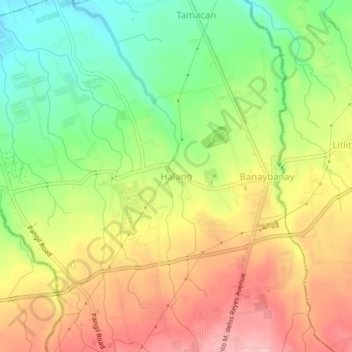
Name: Halang topographic map, elevation, terrain.

Location: Halang, Amadeo, Cavite, Calabarzon, 4119, Philippines (14.18172 120.90616 14.22172 120.94616)

Average elevation: 337 m

Minimum elevation: 265 m

Maximum elevation: 411 m

Gear up for your next adventure:

🥾Hiking Boots - Sturdy boots providing ankle support and traction on rugged trails
🔭Compact Binoculars - Lightweight optics for scouting trails and wildlife
💡LED Headlamp - Hands-free illumination for night hiking and camping
🥾Approach Shoes - Shoes designed for climbing approaches and rugged trails
🧥Ultralight Puffy Jacket - Maximum warmth that packs down to the size of an orange

As an Amazon Associate, this site earns from qualifying purchases at no extra cost to you.