
Make a donation
Gear up for your next adventure:
As an Amazon Associate, this site earns from qualifying purchases at no extra cost to you.
Periya topographic map
Click on the map to display elevation.
Make a donation
Gear up for your next adventure:
As an Amazon Associate, this site earns from qualifying purchases at no extra cost to you.
About this map
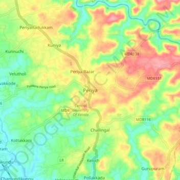
Name: Periya topographic map, elevation, terrain.
Location: Periya, Hosdurg, Kasaragod, Kerala, 671320, India (12.36164 75.05729 12.44164 75.13729)
Average elevation: 60 m
Minimum elevation: 3 m
Maximum elevation: 136 m
Make a donation
Gear up for your next adventure:
As an Amazon Associate, this site earns from qualifying purchases at no extra cost to you.
Other topographic maps
Click on a map to view its topography, its elevation and its terrain.
Kanhangad
India > Kerala > Hosdurg > Kallanchira
Kanhangad lies at 12°18′0″N 75°5.4′0″E in the geographic map of Kasaragod. It is a coastal town which has a varied topography with plain areas in the centre of the city. The landscape is dominated by the characteristic coconut palms accompanying rolling hills and streams flowing into the sea. In the…
Average elevation: 19 m
Make a donation
Gear up for your next adventure:
As an Amazon Associate, this site earns from qualifying purchases at no extra cost to you.
Kanhangad
India > Kerala > Hosdurg > ലക്ഷ്മിനഗരം
Kanhangad lies at 12°18′0″N 75°5.4′0″E in the geographic map of Kasaragod. It is a coastal town which has a varied topography with plain areas in the centre of the city. The landscape is dominated by the characteristic coconut palms accompanying rolling hills and streams flowing into the sea. In the…
Average elevation: 19 m
Kanhangad
India > Kerala > Hosdurg > Kanhangad
Kanhangad lies at 12°18′0″N 75°5.4′0″E in the geographic map of Kasaragod. It is a coastal town which has a varied topography with plain areas in the centre of the city. The landscape is dominated by the characteristic coconut palms accompanying rolling hills and streams flowing into the sea. In the…
Average elevation: 19 m