
Make a donation
Gear up for your next adventure:
As an Amazon Associate, this site earns from qualifying purchases at no extra cost to you.
Telica volcano topographic map
Click on the map to display elevation.
Make a donation
Gear up for your next adventure:
As an Amazon Associate, this site earns from qualifying purchases at no extra cost to you.
Telica volcano
Telica became active in August 1999. An eruption produced ash-fall, and on 18 August a lava lake was observed in the summit crater. The ash eruptions continued until February 2000 and declined afterwards. From 9 January to February 2007, small ash eruptions produced ash clouds reaching altitudes of 4900 ft (1.5 km).
Make a donation
Gear up for your next adventure:
As an Amazon Associate, this site earns from qualifying purchases at no extra cost to you.
About this map
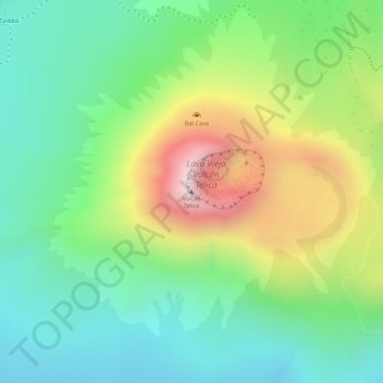
Name: Telica volcano topographic map, elevation, terrain.
Location: Telica volcano, Telica, León, 22400, Nicaragua (12.60436 -86.84422 12.60446 -86.84412)
Average elevation: 658 m
Minimum elevation: 424 m
Maximum elevation: 1,050 m
Make a donation
Gear up for your next adventure:
As an Amazon Associate, this site earns from qualifying purchases at no extra cost to you.