
Make a donation
Gear up for your next adventure:
As an Amazon Associate, this site earns from qualifying purchases at no extra cost to you.
Falkenberg/Elster topographic map
Click on the map to display elevation.
Make a donation
Gear up for your next adventure:
As an Amazon Associate, this site earns from qualifying purchases at no extra cost to you.
About this map
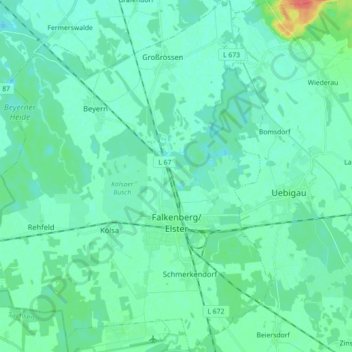
Name: Falkenberg/Elster topographic map, elevation, terrain.
Average elevation: 86 m
Minimum elevation: 78 m
Maximum elevation: 123 m
Make a donation
Gear up for your next adventure:
As an Amazon Associate, this site earns from qualifying purchases at no extra cost to you.
Other topographic maps
Click on a map to view its topography, its elevation and its terrain.
Prestewitz
Deutschland > Brandenburg > Elbe-Elster
Hanssenn Holleufer wurde in einem Lehnsbrief vom 8. Juli 1548 durch Herzog Moritz Prestewitz verliehen, und 1555 verzeichnete der Ort 14 Hufner sowie 3 Gärtner. Im Jahr 1558 verkaufte Friedrich von Holda die sogenannten Dritthalbdörfer Beutersitz, Theisa und Prestewitz an Siegmund von Brandenstein, welcher…
Average elevation: 94 m