Geolocate

Buttenwiesen topographic map

Click on the map to display elevation.

About this map

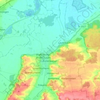
Name: Buttenwiesen topographic map, elevation, terrain.

Location: Buttenwiesen, Landkreis Dillingen an der Donau, Bavaria, 86647, Germany (48.56951 10.63687 48.66289 10.78603)

Average elevation: 426 m

Minimum elevation: 400 m

Maximum elevation: 483 m

Other topographic maps

Click on a map to view its topography, its elevation and its terrain.

Gear up for your next adventure:

🧤Rechargeable Heated Gloves - Extreme warmth for Canadian winter expeditions
Camping Coffee Maker - Brew fresh coffee anywhere on the topographic map
🧭GPS Handheld Device - Reliable GPS navigation for outdoor adventures
🧦Hiking Socks - Moisture-wicking and comfortable socks for long hikes
🧼Biodegradable Camp Soap - Environmentally friendly cleaning for gear and body

As an Amazon Associate, this site earns from qualifying purchases at no extra cost to you.