
Kharkiv city rada topographic map
Interactive map
Click on the map to display elevation.
About this map
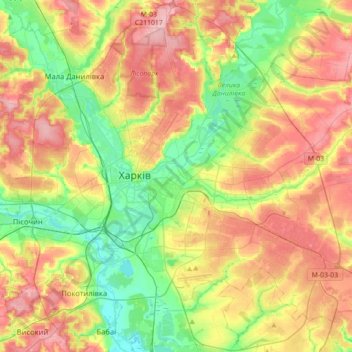
Name: Kharkiv city rada topographic map, elevation, terrain.
Location: Kharkiv city rada, Kharkiv Oblast, Ukraine (49.87828 36.10562 50.10443 36.45606)
Average elevation: 148 m
Minimum elevation: 92 m
Maximum elevation: 212 m
Other topographic maps
Click on a map to view its topography, its elevation and its terrain.