
Lakhimpur topographic map
Click on the map to display elevation.
Lakhimpur
Lakhimpur is located at 27°57′N 80°46′E / 27.95°N 80.77°E / 27.95; 80.77. It has an average elevation of 147 metres (482 ft).
About this map
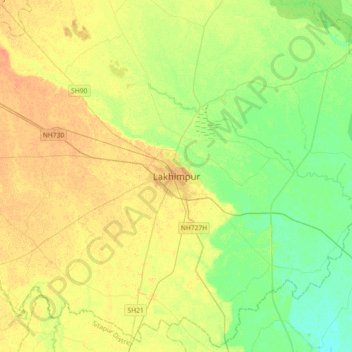
Name: Lakhimpur topographic map, elevation, terrain.
Average elevation: 141 m
Minimum elevation: 126 m
Maximum elevation: 155 m
Other topographic maps
Click on a map to view its topography, its elevation and its terrain.
Mahakali River
India > Uttar Pradesh > Lakhimpur
The Sharda River is the downstream of Kāli River (or Mahakali River) that originates in the northern Uttarakhand state of India in the Great Himalayas on the eastern slopes of Nanda Devi massif, at an elevation of 3,600 m (11,800 ft) in the Pithoragarh district. It then flows on the Nepal and India border.…
Average elevation: 135 m