
Make a donation
Gear up for your next adventure:
As an Amazon Associate, this site earns from qualifying purchases at no extra cost to you.
Borgholzhausen topographic map
Click on the map to display elevation.
Make a donation
Gear up for your next adventure:
As an Amazon Associate, this site earns from qualifying purchases at no extra cost to you.
Borgholzhausen
Der Höhenzug des Teutoburger Waldes trennt an dieser Stelle verschiedene Landschaften, so dass die nördlichen Stadtteile Borgholzhausens im Ravensberger Hügelland liegen, die südlichen in der Ebene des Ostmünsterlands.
Make a donation
Gear up for your next adventure:
As an Amazon Associate, this site earns from qualifying purchases at no extra cost to you.
About this map
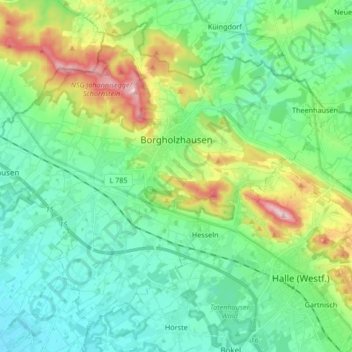
Name: Borgholzhausen topographic map, elevation, terrain.
Average elevation: 133 m
Minimum elevation: 71 m
Maximum elevation: 304 m
Make a donation
Gear up for your next adventure:
As an Amazon Associate, this site earns from qualifying purchases at no extra cost to you.
Other topographic maps
Click on a map to view its topography, its elevation and its terrain.
Schloss Holte
Deutschland > Nordrhein-Westfalen > Kreis Gütersloh > Schloß Holte-Stukenbrock
Das Wasserschloss steht auf einer Insel in einem Hausteich, der vom Ölbach gespeist wird, und besitzt eine eigenwillige Grundrissform, die selbst für die Spätrenaissance und das beginnende Barock ungewöhnlich ist: Das Herrenhaus ist von einer nicht ganz regelmäßig geformten, sechseckigen Ringmauer…
Average elevation: 115 m
Make a donation
Gear up for your next adventure:
As an Amazon Associate, this site earns from qualifying purchases at no extra cost to you.
Oldendorf
Deutschland > Nordrhein-Westfalen > Kreis Gütersloh > Halle (Westf.) > Gartnisch
Average elevation: 152 m
Make a donation
Gear up for your next adventure:
As an Amazon Associate, this site earns from qualifying purchases at no extra cost to you.
Wasserschloss Tatenhausen
Deutschland > Nordrhein-Westfalen > Kreis Gütersloh > Halle (Westf.)
Average elevation: 96 m
Sende
Deutschland > Nordrhein-Westfalen > Kreis Gütersloh > Verl > Sende
Sende liegt auf einer Höhe von 110 m ü. NN am Westrand der Senne südwestlich des Teutoburger Waldes.
Average elevation: 104 m
Make a donation
Gear up for your next adventure:
As an Amazon Associate, this site earns from qualifying purchases at no extra cost to you.
Ascheloh
Deutschland > Nordrhein-Westfalen > Kreis Gütersloh > Halle (Westf.)
Average elevation: 175 m
Gartnisch
Deutschland > Nordrhein-Westfalen > Kreis Gütersloh > Halle (Westf.)
Average elevation: 145 m
Siedlung Determeyer
Deutschland > Nordrhein-Westfalen > Kreis Gütersloh > Gütersloh
Average elevation: 83 m
Amshausen
Deutschland > Nordrhein-Westfalen > Kreis Gütersloh
Zu erwähnen sind das Friedrich-von-Bodelschwingh-Haus mit angrenzendem Kindergarten, der Turn- und Sportverein (TSV) Amshausen, der Tennisclub (TC) Amshausen, die Begegnungsstätten Alte Feuerwehr und Landeplatz, die Freiwillige Feuerwehr, die Friedrichshöhe und die Firma Hörmann.
Average elevation: 146 m
Make a donation
Gear up for your next adventure:
As an Amazon Associate, this site earns from qualifying purchases at no extra cost to you.