
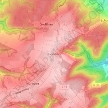
Kleinhau topographic map
Interactive map
Click on the map to display elevation.
About this map
Name: Kleinhau topographic map, elevation, terrain.
Average elevation: 357 m
Minimum elevation: 215 m
Maximum elevation: 404 m
Other topographic maps
Click on a map to view its topography, its elevation and its terrain.
Zerkall
Deutschland > Nordrhein-Westfalen > Kreis Düren > Hürtgenwald
Zerkall, Hürtgenwald, Kreis Düren, Nordrhein-Westfalen, 52385, Deutschland
Average elevation: 276 m
Horm
Deutschland > Nordrhein-Westfalen > Kreis Düren > Hürtgenwald
Horm, Hürtgenwald, Kreis Düren, Nordrhein-Westfalen, 52355, Deutschland
Average elevation: 227 m
Gey
Deutschland > Nordrhein-Westfalen > Kreis Düren > Hürtgenwald
Gey, Hürtgenwald, Kreis Düren, Nordrhein-Westfalen, 52393, Deutschland
Average elevation: 259 m
Vossenack
Deutschland > Nordrhein-Westfalen > Kreis Düren > Hürtgenwald
Vossenack, Hürtgenwald, Kreis Düren, Nordrhein-Westfalen, 52393, Deutschland
Average elevation: 380 m
Bergstein
Deutschland > Nordrhein-Westfalen > Kreis Düren > Hürtgenwald > Bergstein
Bergstein, Hürtgenwald, Kreis Düren, Nordrhein-Westfalen, 52393, Deutschland
Average elevation: 297 m
Ochsenkopf
Deutschland > Nordrhein-Westfalen > Kreis Düren > Hürtgenwald
Ochsenkopf, Hürtgenwald, Kreis Düren, Nordrhein-Westfalen, Deutschland
Average elevation: 440 m
Simonskall
Deutschland > Nordrhein-Westfalen > Kreis Düren > Hürtgenwald
Simonskall, Hürtgenwald, Kreis Düren, Nordrhein-Westfalen, 52393, Deutschland
Average elevation: 429 m
Großhau
Deutschland > Nordrhein-Westfalen > Kreis Düren > Hürtgenwald
Großhau, Hürtgenwald, Kreis Düren, Nordrhein-Westfalen, 52393, Deutschland
Average elevation: 345 m
Hürtgen
Deutschland > Nordrhein-Westfalen > Kreis Düren > Hürtgenwald
Hürtgen, Hürtgenwald, Kreis Düren, Nordrhein-Westfalen, 52393, Deutschland
Average elevation: 371 m