Geolocate

Yera topographic map

Click on the map to display elevation.

About this map

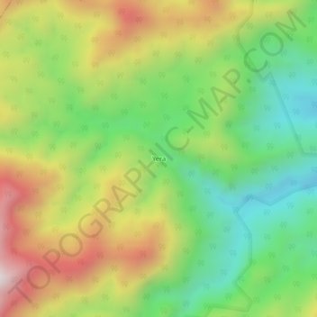
Name: Yera topographic map, elevation, terrain.

Location: Yera, Teorama, Occidente, Norte de Santander, Colombia (8.95409 -73.13577 8.99409 -73.09577)

Average elevation: 674 m

Minimum elevation: 276 m

Maximum elevation: 1,214 m

Gear up for your next adventure:

🧭GPS Handheld Device - Reliable GPS navigation for outdoor adventures
🧤Thermal Hiking Gloves - Grip-enhanced gloves for cold-weather altitude trekking
🥽Outdoor Goggles - Protective eyewear for outdoor activities
Backpacking Tent - Lightweight tent for long-distance hiking trips
🥾Approach Boots - Comfortable boots for hiking and climbing approaches

As an Amazon Associate, this site earns from qualifying purchases at no extra cost to you.