Geolocate

Warren topographic map

Click on the map to display elevation.

About this map
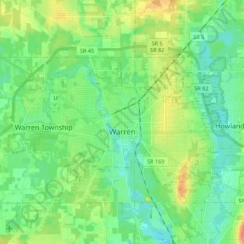
Name: Warren topographic map, elevation, terrain.

Location: Warren, Trumbull County, Ohio, United States (41.21086 -80.89400 41.27205 -80.74049)

Average elevation: 277 m

Minimum elevation: 257 m

Maximum elevation: 324 m

Other topographic maps

Click on a map to view its topography, its elevation and its terrain.
Howland Township

United States > Ohio > Trumbull County

Average elevation: 299 m

Vienna

United States > Ohio > Trumbull County

Average elevation: 342 m

Vienna Township

United States > Ohio > Trumbull County

Average elevation: 342 m

Burghill

United States > Ohio > Trumbull County > Vernon Township

Average elevation: 311 m

Gear up for your next adventure:

👟Sport Hiking Sandals - Breathable footwear for water crossings and camp rest
🧼Travel Hand Sanitizer - Keep hands clean when water is scarce
🕶️Polarized Sunglasses - Reduces glare from snow and water at high elevations
⛺Camping Tent - Weather-resistant tents suitable for 2 to 6 people
🩹Moleskin Blister Pads - Direct protection for painful foot pressure points

As an Amazon Associate, this site earns from qualifying purchases at no extra cost to you.