Geolocate

Pingtang topographic map

Click on the map to display elevation.

About this map

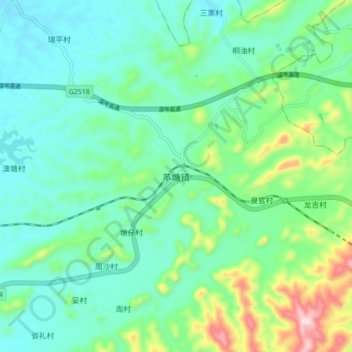
Name: Pingtang topographic map, elevation, terrain.

Location: Pingtang, Luoding, Yunfu City, Guangdong Province, China (22.71344 111.71120 22.79344 111.79120)

Average elevation: 131 m

Minimum elevation: 42 m

Maximum elevation: 408 m

Gear up for your next adventure:

🧴First Aid Kit - Essential first aid supplies for outdoor emergencies
🥾Light Hiking Boots - Lightweight and comfortable boots for day hikes
Bushcraft Tarp - Versatile emergency shelter or gear protection
🧴Waterproofing Spray - Restore the DWR coating on jackets and tents
🔪Outdoor Multitool - Versatile tool for repairs and food prep in the wild

As an Amazon Associate, this site earns from qualifying purchases at no extra cost to you.