Geolocate

San Pedro topographic map

Click on the map to display elevation.

About this map

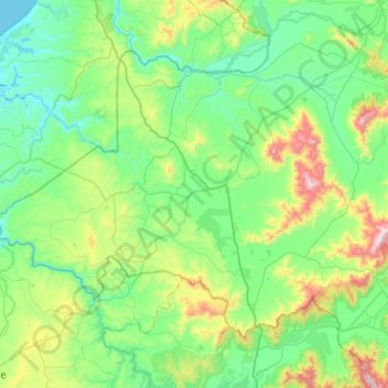
Name: San Pedro topographic map, elevation, terrain.

Location: San Pedro, Provincia de Melipilla, Santiago Metropolitan Region, Chile (-34.07580 -71.71485 -33.76402 -71.20703)

Average elevation: 214 m

Minimum elevation: 0 m

Maximum elevation: 1,014 m

Other topographic maps

Click on a map to view its topography, its elevation and its terrain.

Gear up for your next adventure:

🔪Outdoor Multitool - Versatile tool for repairs and food prep in the wild
👖Convertible Hiking Pants - Zip-off legs to adapt to changing weather conditions
🥾Lightweight Hiking Boots - Boots for comfort and mobility on long hikes
🧤Insulated Winter Gloves - Heavy-duty protection for sub-zero Canadian adventures
🔋Lithium AA Batteries - Long-lasting power that performs in extreme cold

As an Amazon Associate, this site earns from qualifying purchases at no extra cost to you.