
Make a donation
Gear up for your next adventure:
As an Amazon Associate, this site earns from qualifying purchases at no extra cost to you.
Epagny topographic map
Click on the map to display elevation.
Make a donation
Gear up for your next adventure:
As an Amazon Associate, this site earns from qualifying purchases at no extra cost to you.
About this map
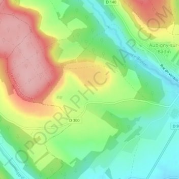
Name: Epagny topographic map, elevation, terrain.
Average elevation: 341 m
Minimum elevation: 275 m
Maximum elevation: 424 m
Make a donation
Gear up for your next adventure:
As an Amazon Associate, this site earns from qualifying purchases at no extra cost to you.
Other topographic maps
Click on a map to view its topography, its elevation and its terrain.
Montsaugeon
France > Grand Est > Haute-Marne > Le Montsaugeonnais
Montsaugeon est situé sur l'ancien pagus bourguigon de l'Attouar ou de l'Atuyer qui est resté un lieu de passage antique entre les vallées du Rhône et du Rhin, une espèce de col à 338 mètres d'altitude entre les deux mers, enjeu de luttes et d'incursions stratégiques qui provoquèrent la construction…
Average elevation: 296 m
Make a donation
Gear up for your next adventure:
As an Amazon Associate, this site earns from qualifying purchases at no extra cost to you.