
Make a donation
Gear up for your next adventure:
As an Amazon Associate, this site earns from qualifying purchases at no extra cost to you.
04190 topographic map
Click on the map to display elevation.
Make a donation
Gear up for your next adventure:
As an Amazon Associate, this site earns from qualifying purchases at no extra cost to you.
About this map
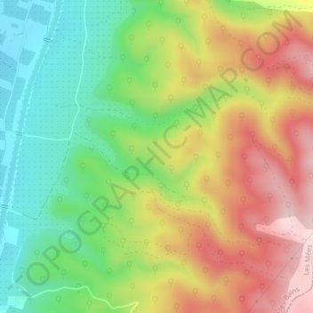
Name: 04190 topographic map, elevation, terrain.
Average elevation: 550 m
Minimum elevation: 350 m
Maximum elevation: 857 m
Make a donation
Gear up for your next adventure:
As an Amazon Associate, this site earns from qualifying purchases at no extra cost to you.
Other topographic maps
Click on a map to view its topography, its elevation and its terrain.
Les Varzelles
France > Provence-Alpes-Côte d'Azur > Alpes-de-Haute-Provence > Les Mées
Average elevation: 473 m
Dabisse
France > Provence-Alpes-Côte d'Azur > Alpes-de-Haute-Provence > Les Mées
Average elevation: 419 m
La Chauchière
France > Provence-Alpes-Côte d'Azur > Alpes-de-Haute-Provence > Les Mées
Average elevation: 463 m
La Roberte
France > Provence-Alpes-Côte d'Azur > Alpes-de-Haute-Provence > Les Mées
Average elevation: 505 m
Make a donation
Gear up for your next adventure:
As an Amazon Associate, this site earns from qualifying purchases at no extra cost to you.