
Heidenau topographic map
Click on the map to display elevation.
About this map
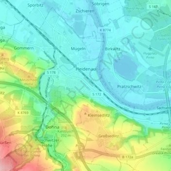
Name: Heidenau topographic map, elevation, terrain.
Location: Heidenau, Sächsische Schweiz-Osterzgebirge, Saxony, Germany (50.94354 13.82100 50.99294 13.90658)
Average elevation: 150 m
Minimum elevation: 110 m
Maximum elevation: 267 m
Other topographic maps
Click on a map to view its topography, its elevation and its terrain.
Saxon Switzerland
Germany > Saxony > Sächsische Schweiz-Osterzgebirge
Saxon Switzerland forms the northern part of the Elbe Sandstone Mountains range, located on the German-Czech border. To the east, it transitions into the Lusatian Highlands and, to the west, into the Ore Mountains. The Czech part of the Elbe Sandstone Mountains is partly formed by the Bohemian Switzerland…
Average elevation: 341 m
Reinhardtsgrimma
Germany > Saxony > Sächsische Schweiz-Osterzgebirge > Glashütte
Average elevation: 372 m
Berreuth
Germany > Saxony > Sächsische Schweiz-Osterzgebirge > Dippoldiswalde
Average elevation: 388 m
Topograph
Germany > Saxony > Sächsische Schweiz-Osterzgebirge > Rosenthal-Bielatal
Average elevation: 385 m
Siamesische Zwillinge, Dick
Germany > Saxony > Sächsische Schweiz-Osterzgebirge > Bad Schandau
Average elevation: 366 m