
Hohentengen topographic map
Interactive map
Click on the map to display elevation.
About this map
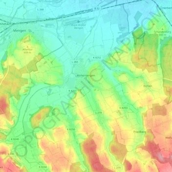
Name: Hohentengen topographic map, elevation, terrain.
Average elevation: 589 m
Minimum elevation: 546 m
Maximum elevation: 664 m
Other topographic maps
Click on a map to view its topography, its elevation and its terrain.
Hornstein
Duitsland > Baden-Württemberg > Landkreis Sigmaringen > Bingen
Hornstein, Bingen, Gemeindeverwaltungsverband Sigmaringen, Landkreis Sigmaringen, Baden-Württemberg, 72511, Duitsland
Average elevation: 657 m