
Kent topographic map
Interactive map
Click on the map to display elevation.
About this map
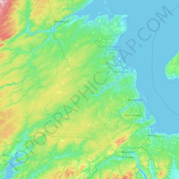
Name: Kent topographic map, elevation, terrain.
Location: Kent, Kent County, Nuovo Brunswick, Canada (45.90252 -65.83952 47.18252 -64.55952)
Average elevation: 52 m
Minimum elevation: -4 m
Maximum elevation: 365 m
Other topographic maps
Click on a map to view its topography, its elevation and its terrain.
Saint John
Canada > Nuovo Brunswick > Saint John
Saint John, City of Saint John, Saint John County, Nuovo Brunswick, Canada
Average elevation: 39 m
Fundy National Park
Fundy National Park, 114, Albert County, Nuovo Brunswick, E4H 1N5, Canada
Average elevation: 230 m