
Make a donation
Gear up for your next adventure:
As an Amazon Associate, this site earns from qualifying purchases at no extra cost to you.
96515 topographic map
Click on the map to display elevation.
Make a donation
Gear up for your next adventure:
As an Amazon Associate, this site earns from qualifying purchases at no extra cost to you.
About this map
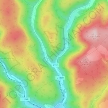
Name: 96515 topographic map, elevation, terrain.
Location: 96515, Sonneberg, Landkreis Sonneberg, Thüringen, Deutschland (50.41407 11.20087 50.41417 11.20097)
Average elevation: 579 m
Minimum elevation: 443 m
Maximum elevation: 722 m
Make a donation
Gear up for your next adventure:
As an Amazon Associate, this site earns from qualifying purchases at no extra cost to you.
Other topographic maps
Click on a map to view its topography, its elevation and its terrain.
Spechtsbrunn
Deutschland > Thüringen > Landkreis Sonneberg > Sonneberg
Kurz nach der Wiedervereinigung begann der neugegründete hiesige Tourismusverein in Zusammenarbeit mit den Gasthäusern und einigen privaten Vermietern einen sanften Tourismus aufzubauen. Der ehemalige Grenzstreifen, das „Grüne Band“, sowie der Rennsteig und die Alte Heer- und Handelsstraße sind für…
Average elevation: 676 m
Make a donation
Gear up for your next adventure:
As an Amazon Associate, this site earns from qualifying purchases at no extra cost to you.
Haselbach
Deutschland > Thüringen > Landkreis Sonneberg > Sonneberg > Haselbach
Average elevation: 604 m
Make a donation
Gear up for your next adventure:
As an Amazon Associate, this site earns from qualifying purchases at no extra cost to you.