
Make a donation
Gear up for your next adventure:
As an Amazon Associate, this site earns from qualifying purchases at no extra cost to you.
Pollock topographic map
Click on the map to display elevation.
Make a donation
Gear up for your next adventure:
As an Amazon Associate, this site earns from qualifying purchases at no extra cost to you.
About this map
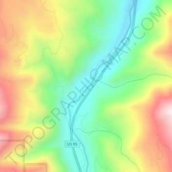
Name: Pollock topographic map, elevation, terrain.
Location: Pollock, Idaho County, Idaho, 83547, United States (45.30239 -116.36902 45.32239 -116.34902)
Average elevation: 913 m
Minimum elevation: 681 m
Maximum elevation: 1,223 m
Make a donation
Gear up for your next adventure:
As an Amazon Associate, this site earns from qualifying purchases at no extra cost to you.
Other topographic maps
Click on a map to view its topography, its elevation and its terrain.
Kooskia
United States > Idaho > Idaho County
Kooskia is located at 46°8′30″N 115°58′47″W / 46.14167°N 115.97972°W / 46.14167; -115.97972 (46.139, -115.979), at an elevation of 1,293 feet (394 m) [above sea level.
Average elevation: 459 m
Ferdinand
United States > Idaho > Idaho County
Ferdinand is located at 46°9′10″N 116°23′26″W / 46.15278°N 116.39056°W / 46.15278; -116.39056 (46.152701, -116.390438), at an elevation of 3,720 feet (1,130 m) above sea level on the Camas Prairie.
Average elevation: 1,148 m
Make a donation
Gear up for your next adventure:
As an Amazon Associate, this site earns from qualifying purchases at no extra cost to you.