Geolocate

Alaró topographic map

Click on the map to display elevation.

About this map

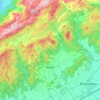
Name: Alaró topographic map, elevation, terrain.

Location: Alaró, Raiguer, Balearic Islands, 07340, Spain (39.67227 2.75265 39.77520 2.85066)

Average elevation: 401 m

Minimum elevation: 40 m

Maximum elevation: 1,102 m

Other topographic maps

Click on a map to view its topography, its elevation and its terrain.

Gear up for your next adventure:

💧Reusable Water Bottle - Durable water bottles for hydration on trails
🧥Waterproof Pants - Keep dry during rainy hiking conditions
🧴First Aid Kit - Essential first aid supplies for outdoor emergencies
💧Filtered Water Bottle - Safe drinking water on the go
🧊Insulated Water Bottle - Keeps drinks cold in summer and prevents freezing in winter

As an Amazon Associate, this site earns from qualifying purchases at no extra cost to you.