Geolocate

Te Haroto topographic map

Click on the map to display elevation.

About this map

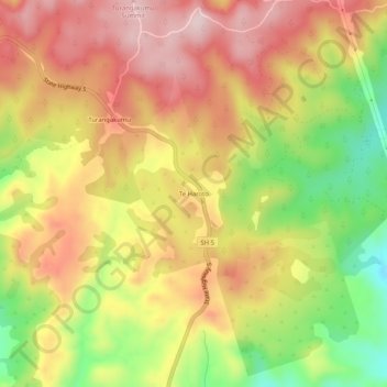
Name: Te Haroto topographic map, elevation, terrain.

Location: Te Haroto, Hastings District, Hawke's Bay, New Zealand (-39.14584 176.58564 -39.10584 176.62564)

Average elevation: 647 m

Minimum elevation: 460 m

Maximum elevation: 792 m

Other topographic maps

Click on a map to view its topography, its elevation and its terrain.

Kaweka Range

New Zealand > Hawke's Bay > Hastings District

Average elevation: 1,138 m

Gear up for your next adventure:

🥾Durable Hiking Shoes - Long-lasting shoes for frequent hiking
🥫Freeze-Dried Meals - Lightweight, high-calorie nutrition for multi-day treks
🧢Outdoor Cap - Protective cap for sun and rain during hikes
🥾Hiking Shorts - Breathable shorts suitable for summer hikes
🧥Softshell Jacket - Windproof and breathable jacket for hiking

As an Amazon Associate, this site earns from qualifying purchases at no extra cost to you.