
Make a donation
Gear up for your next adventure:
As an Amazon Associate, this site earns from qualifying purchases at no extra cost to you.
88120 topographic map
Click on the map to display elevation.
Make a donation
Gear up for your next adventure:
As an Amazon Associate, this site earns from qualifying purchases at no extra cost to you.
About this map
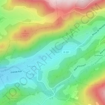
Name: 88120 topographic map, elevation, terrain.
Average elevation: 580 m
Minimum elevation: 425 m
Maximum elevation: 845 m
Make a donation
Gear up for your next adventure:
As an Amazon Associate, this site earns from qualifying purchases at no extra cost to you.
Other topographic maps
Click on a map to view its topography, its elevation and its terrain.
Le Haut du Tôt
France > Grand Est > Vosges > Sapois
Perché à 827 m d'altitude dans le massif des Vosges sur le versant nord de la vallée de la Moselotte, le Haut du Tôt est la plus haute paroisse du département des Vosges. Il ne constitue cependant pas une commune, ayant été partagé arbitrairement par une ligne nord-sud entre Vagney et Sapois.
Average elevation: 746 m
Make a donation
Gear up for your next adventure:
As an Amazon Associate, this site earns from qualifying purchases at no extra cost to you.