
Make a donation
Gear up for your next adventure:
As an Amazon Associate, this site earns from qualifying purchases at no extra cost to you.
Ridgely topographic map
Click on the map to display elevation.
Make a donation
Gear up for your next adventure:
As an Amazon Associate, this site earns from qualifying purchases at no extra cost to you.
Ridgely
A post office called Ridgely was established in 1848, and remained in operation until 1902. The community most likely was so named on account of its lofty elevation.
Make a donation
Gear up for your next adventure:
As an Amazon Associate, this site earns from qualifying purchases at no extra cost to you.
About this map
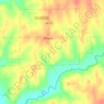
Name: Ridgely topographic map, elevation, terrain.
Location: Ridgely, Platte County, Missouri, United States (39.44078 -94.65694 39.46318 -94.62364)
Average elevation: 277 m
Minimum elevation: 246 m
Maximum elevation: 299 m
Make a donation
Gear up for your next adventure:
As an Amazon Associate, this site earns from qualifying purchases at no extra cost to you.
Other topographic maps
Click on a map to view its topography, its elevation and its terrain.