Geolocate

Travers topographic map

Click on the map to display elevation.

About this map

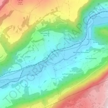
Name: Travers topographic map, elevation, terrain.

Location: Travers, Val-de-Travers, Neuchâtel, 2105, Suisse (46.92133 6.65636 46.96133 6.69636)

Average elevation: 927 m

Minimum elevation: 721 m

Maximum elevation: 1,330 m

Gear up for your next adventure:

🕶️Polarized Sunglasses - Protect your eyes with durable polarized lenses
💧Hydration Bladder - Hands-free hydration solution for long treks
👟Trail Running Shoes - Agile footwear for fast-paced topographic exploration
🛶Waterproof Dry Bags - Keep electronics and clothes dry during river crossings
🎒Backpack Rain Cover - External shield to keep your entire pack dry

As an Amazon Associate, this site earns from qualifying purchases at no extra cost to you.