
Make a donation
Gear up for your next adventure:
As an Amazon Associate, this site earns from qualifying purchases at no extra cost to you.
St. Jakob topographic map
Click on the map to display elevation.
Make a donation
Gear up for your next adventure:
As an Amazon Associate, this site earns from qualifying purchases at no extra cost to you.
About this map
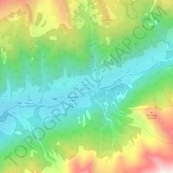
Name: St. Jakob topographic map, elevation, terrain.
Location: St. Jakob, Pfitsch, Wipptal, Bozen, Trentino-Südtirol, Italien (46.94902 11.58274 46.98902 11.62274)
Average elevation: 1,809 m
Minimum elevation: 1,399 m
Maximum elevation: 2,590 m
Make a donation
Gear up for your next adventure:
As an Amazon Associate, this site earns from qualifying purchases at no extra cost to you.
Other topographic maps
Click on a map to view its topography, its elevation and its terrain.
Pfitsch
Italien > Trentino-Südtirol > Bozen > Pfitsch
Das erste Teilstück der Berge, die das Pfitscher Tal im Nordwesten und Norden begrenzen, ist der Tuxer Kamm. Zu den bedeutendsten Gipfeln hier zählen die Weißspitze (2714 m), das Hühnerspiel (2790 m), die Rollspitze (2776 m), die Kalkwandstange (2386 m), die Flatschspitze (2570 m) und der Wolfendorn (2776…
Average elevation: 1,953 m