
Wetlina topographic map
Interactive map
Click on the map to display elevation.
About this map
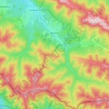
Name: Wetlina topographic map, elevation, terrain.
Average elevation: 857 m
Minimum elevation: 570 m
Maximum elevation: 1,235 m
The village is located near the source (springs) of the Weltinka river, a primary tributary of the Solinka river. South and west of the village are the Sękowa (1022 m) and Paprotna (1193 m) mountain peaks. East of the village are the range peaks of Połonina Wetlińska, with a maximum elevation of 1253 m.