
Thank you for supporting this site ❤️
Make a donation
Make a donation
Gear up for your next adventure:
As an Amazon Associate, this site earns from qualifying purchases at no extra cost to you.
Saldanxe topographic map
Click on the map to display elevation.
Thank you for supporting this site ❤️
Make a donation
Make a donation
Gear up for your next adventure:
As an Amazon Associate, this site earns from qualifying purchases at no extra cost to you.
About this map
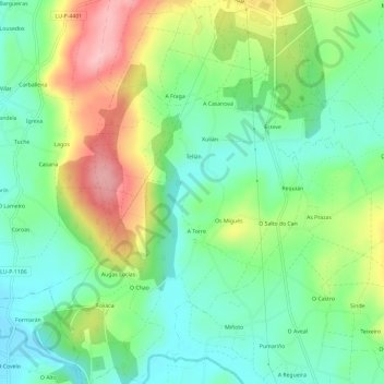
Name: Saldanxe topographic map, elevation, terrain.
Location: Saldanxe, A Pastoriza, Terra Chá, Lugo, Galicien, Spanien (43.25574 -7.37139 43.29864 -7.32745)
Average elevation: 479 m
Minimum elevation: 419 m
Maximum elevation: 585 m
Thank you for supporting this site ❤️
Make a donation
Make a donation
Gear up for your next adventure:
As an Amazon Associate, this site earns from qualifying purchases at no extra cost to you.