
Make a donation
Gear up for your next adventure:
As an Amazon Associate, this site earns from qualifying purchases at no extra cost to you.
Schuylkill Haven topographic map
Click on the map to display elevation.
Make a donation
Gear up for your next adventure:
As an Amazon Associate, this site earns from qualifying purchases at no extra cost to you.
Schuylkill Haven
Schuylkill Haven was developed around the Schuylkill River, which flows through the town entering northwest of Island Park near Fritz Reed Avenue, and exits at the southeastern border. The river's elevation in the borough is approximately 490 feet (150 m) above sea level. Farther from the river, the borough extends up numerous hills, reaching its highest elevation at approximately 700 feet (210 m) above sea level near the top of Avenue C.
Make a donation
Gear up for your next adventure:
As an Amazon Associate, this site earns from qualifying purchases at no extra cost to you.
About this map
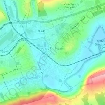
Name: Schuylkill Haven topographic map, elevation, terrain.
Average elevation: 184 m
Minimum elevation: 147 m
Maximum elevation: 287 m
Make a donation
Gear up for your next adventure:
As an Amazon Associate, this site earns from qualifying purchases at no extra cost to you.