
Make a donation
Gear up for your next adventure:
As an Amazon Associate, this site earns from qualifying purchases at no extra cost to you.
Cheat Lake topographic map
Click on the map to display elevation.
Make a donation
Gear up for your next adventure:
As an Amazon Associate, this site earns from qualifying purchases at no extra cost to you.
About this map
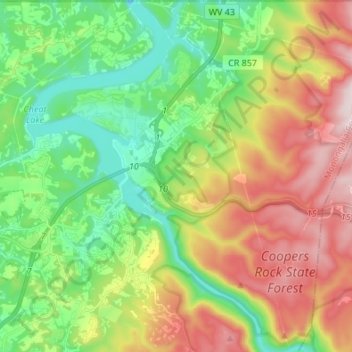
Name: Cheat Lake topographic map, elevation, terrain.
Location: Cheat Lake, Monongalia County, West Virginia, United States (39.61640 -79.90348 39.72066 -79.81202)
Average elevation: 440 m
Minimum elevation: 236 m
Maximum elevation: 756 m
Make a donation
Gear up for your next adventure:
As an Amazon Associate, this site earns from qualifying purchases at no extra cost to you.
Other topographic maps
Click on a map to view its topography, its elevation and its terrain.
South Hills
United States > West Virginia > Monongalia County > Morgantown > South Hills
Average elevation: 312 m
Make a donation
Gear up for your next adventure:
As an Amazon Associate, this site earns from qualifying purchases at no extra cost to you.