Geolocate

Talwara topographic map

Click on the map to display elevation.

Talwara

Talwara is located at 31°57′N 75°52′E / 31.95°N 75.87°E / 31.95; 75.87. It has an average elevation of 326 metres (1069 ft).

Wikipedia (CC-BY-SA 3.0)

About this map

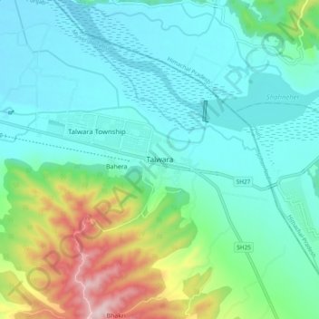
Name: Talwara topographic map, elevation, terrain.

Location: Talwara, Mukerian Tahsil, Hoshiarpur District, Punjab, 144216, India (31.90331 75.84058 31.98331 75.92058)

Average elevation: 392 m

Minimum elevation: 310 m

Maximum elevation: 665 m

Gear up for your next adventure:

🧦Crew Hiking Socks - Comfortable socks for long-distance hikes
🧴Outdoor Sunscreen - High SPF protection for high-altitude UV exposure
🥾Light Hiking Boots - Lightweight and comfortable boots for day hikes
Camping Coffee Maker - Brew fresh coffee anywhere on the topographic map
🧭GPS Tracker - Track your location in remote areas safely

As an Amazon Associate, this site earns from qualifying purchases at no extra cost to you.